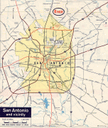
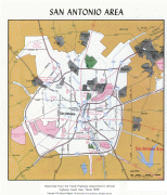
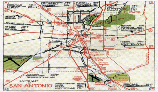
San Antonio (San Antonio)
 |
 |
Founded as a Spanish mission and colonial outpost in 1718, the city in 1731 became the first chartered civil settlement in what is now present-day Texas. The area was then part of the Spanish Empire. From 1821 to 1836, it was part of the Mexican Republic. It is the oldest municipality in Texas, having celebrated its 300th anniversary on May 1, 2018.
From 2000 to 2010, the city was the fastest growing of the top ten largest cities in the United States; it was the second in growth in that category from 1990 to 2000. The city of San Antonio serves as the seat of Bexar County; San Antonio is the center of the San Antonio–New Braunfels metropolitan statistical area. Commonly called Greater San Antonio, the metropolitan area had a population of 2,601,788 based on the 2020 U.S. census estimates, making it the 24th-largest metropolitan area in the United States and third-largest in Texas.
Straddling the regional divide between South and Central Texas, San Antonio anchors the southwestern corner of an urban megaregion colloquially known as the Texas Triangle. Downtown San Antonio and Downtown Austin are approximately 80 mi apart, both falling along the Interstate 35 corridor. Some observers expect the two metropolitan regions to form a new metroplex similar to Dallas and Fort Worth.
San Antonio was named by a 1691 Spanish expedition for the Portuguese priest Saint Anthony of Padua, whose feast day is June 13. The city contains five 18th-century Spanish frontier missions, including The Alamo and San Antonio Missions National Historical Park. Together these were designated as UNESCO World Heritage sites in 2015. Other notable attractions include the River Walk, the Tower of the Americas, SeaWorld San Antonio, the Alamo Bowl, and Marriage Island. Commercial entertainment includes Six Flags Fiesta Texas and Morgan's Wonderland amusement parks. According to the San Antonio Convention and Visitors Bureau, the city is visited by about 32 million tourists a year. It is home to the five-time National Basketball Association (NBA) champion San Antonio Spurs. It hosts the annual San Antonio Stock Show & Rodeo, one of the largest such events in the U.S.
The U.S. Armed Forces have numerous facilities in and around San Antonio; Fort Sam Houston, which has Brooke Army Medical Center within it, is the only one within the city limits. Lackland Air Force Base, Randolph Air Force Base, Kelly Air Force Base, Camp Bullis, and Camp Stanley are outside the city limits. San Antonio is home to four Fortune 500 companies and the South Texas Medical Center, the only medical research and care provider in the South Texas region.
San Antonio is also the largest majority-Hispanic city in the United States, with 64% of its population being Hispanic.
At the time of European encounter, the Payaya people lived near the San Antonio River Valley in the San Pedro Springs area. They called the vicinity Yanaguana, meaning "refreshing waters". In 1691, a group of Spanish explorers and missionaries came upon the river and Payaya settlement on June 13, the feast day of St. Anthony of Padua. They named the place and river "San Antonio" in his honor.
It was years before any Spanish settlement took place. Father Antonio de Olivares visited the site in 1709, and he was determined to found a mission and civilian settlement there. The viceroy gave formal approval for a combined mission and presidio in late 1716, as he wanted to forestall any French expansion into the area from their colony of La Louisiane to the east, as well as prevent illegal trading with the Payaya. He directed Martín de Alarcón, the governor of Coahuila y Tejas, to establish the mission complex. Differences between Alarcón and Olivares resulted in delays, and construction did not start until 1718. Olivares built, with the help of the Payaya and the Pastia people, the Misión de San Antonio de Valero (The Alamo), the Presidio San Antonio de Bexar, the bridge that connected both, and the Acequia Madre de Valero.
The families who clustered around the presidio and mission were the start of Villa de Béjar, destined to become the most important town in Spanish Texas. On May 1, the governor transferred ownership of the Mission San Antonio de Valero (later famous as The Alamo) to Fray Antonio de Olivares. On May 5, 1718, he commissioned the Presidio San Antonio de Béxar ("Béjar" in modern Spanish orthography) on the west side of the San Antonio River, one-fourth league from the mission.
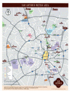
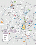
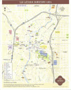
Map - San Antonio (San Antonio)
Map


Country - United_States
 |
 |
| Flag of the United States | |
Indigenous peoples have inhabited the Americas for thousands of years. Beginning in 1607, British colonization led to the establishment of the Thirteen Colonies in what is now the Eastern United States. They quarreled with the British Crown over taxation and political representation, leading to the American Revolution and proceeding Revolutionary War. The United States declared independence on July 4, 1776, becoming the first nation-state founded on Enlightenment principles of unalienable natural rights, consent of the governed, and liberal democracy. The country began expanding across North America, spanning the continent by 1848. Sectional division surrounding slavery in the Southern United States led to the secession of the Confederate States of America, which fought the remaining states of the Union during the American Civil War (1861–1865). With the Union's victory and preservation, slavery was abolished nationally by the Thirteenth Amendment.
Currency / Language
| ISO | Currency | Symbol | Significant figures |
|---|---|---|---|
| USD | United States dollar | $ | 2 |
| ISO | Language |
|---|---|
| EN | English language |
| FR | French language |
| ES | Spanish language |